The 2025 North Atlantic hurricane season was dominated by a combination of unnamed tropical storms and ‘major’ hurricanes. What caused the absence of ‘moderate’ (Category 1 to 3) hurricanes this year?
The final tally for the 2025 North Atlantic hurricane season ended up including eight tropical storms, one category 4 hurricane (Gabrielle) and three category 5 hurricanes (Erin, Humberto, Melissa). Only one event, Hurricane Imelda, fell into the intensity classes sometimes described as “moderate” hurricane (categories 1, 2 and 3). Is the near absence of moderate hurricanes in 2025, part of a long-term trend of changing storm intensities?
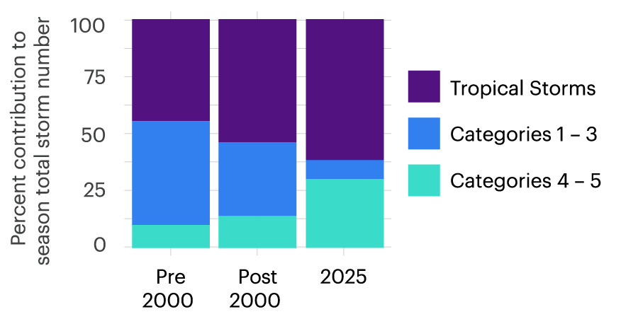
The historical record provides evidence that minor hurricanes are being squeezed out by weaker tropical storms and the strongest hurricanes. Figure 1 shows that the proportion of hurricanes reaching moderate intensities (Categories 1 to 3) is shrinking. Over the 30-year period between 1970 and 1999, the typical proportion of moderate intensity hurricanes in a given year was 45% (Figure 1). Over the more recent 2000 to 2025 period, this proportion lowered to 33%. The contributions of moderate intensity storms to the overall season are being replaced by a higher proportion of both the weakest and the strongest storms
Figure 1 – Percent contributions to the total number of North Atlantic season storms from three intensity categories; (a) tropical storms, (b) categories 1, 2 and 3 and (c) categories 4 and 5. The three stacked bars are averaged over the periods 1970-1999, 2000 – 2025 and 2025 only. Data are sourced from the International Best Track Archive for Climate Stewardship.[1]
The 2025 season (shown in the rightmost column of Figure 1) is an extreme example of this recent tendency towards “disappearing” moderate hurricanes. Category 2 Imelda represents just 8% of the season’s total of 13 storms. Tropical storms contributed 62% and categories 4 and 5 combined contributed 31%. How is it possible that the number of both the weaker tropical storms and strongest hurricanes would be increasing at the same time? To explore this conundrum, we consider the volatility of hurricanes.
A more favorable environment
We’ve known for a long time that hurricanes are fueled by ocean heat. The observed increases in ocean heat in the North Atlantic basin are supportive of stronger hurricanes. For hurricanes to reach their full potential, however, the atmospheric environment (e.g., wind shear, humidity) must also be supportive. Whereas the ocean heat is generally sustained throughout the hurricane season, supportive atmospheric conditions are fleeting. Those rapid changes in atmospheric conditions explain why we don’t have hurricanes everywhere all the time during the season.
Many storms are capped at low-end intensities by atmospheric conditions that are only marginally favorable. These windows of supportive atmosphere don’t have to last long to produce a major hurricane — most major hurricanes rapidly intensify within a day or so. Historically, large parts of the North Atlantic
Ocean were cooler and could only support storms up to minor hurricane strength. But now that the heat content of the North Atlantic is consistently higher overall, more parts of the surface ocean are able to fuel storms up to category 4 or 5 strength. Put simply, environmental conditions that would support a hurricane only up to categories 1, 2 or 3 are becoming scarce
How 2025 will help expand the hurricane rule book
The goal of hurricane science is to explain the “rules” of hurricane behavior. The 2025 season was an additional and important data point that will allow us to fill in more of the hurricane rule book. Conducting hurricane science is analogous to watching a football match with no prior knowledge of the rules. Watching a single match will give some clues to the rules. Watching the entire football season could allow new fans to write down their understanding of some of those rules. In the same way, analyzing larger collections of hurricane seasons allows us to write more of the hurricane rule book. Analysis of the 2025 season will allow us specifically to understand better the rule of volatility.
In the November 2024 WTW newsletter article ‘Why Increasing Variability in North Atlantic Hurricanes Matters for Insurance Climate Change Scenarios’, Cameron Rye (Willis Re) and Jessica Boyd (Willis Research Network) demonstrated that the rare loss exceedance probabilities are far more sensitive to changes in hazard variability than to changes in the mean hazard[2]. Increasing hurricane season volatility, where already-active seasons see the largest increases in activity, has the potential to vastly stretch out the tail of the loss distribution. We also have evidence that hurricane volatility may continue to increase in the future.[3]
Of course, impacts result from storms making landfall. Throughout the 2025 season a persistent trough of low pressure over the Southeastern United States steered storms away from the U.S. coastline. History tells us that these protective steering winds are not present every year. When the tropical Pacific Ocean is in its La Niña phase, environmental winds in the North Atlantic tend to steer storms towards the United States. With ongoing warming and a continued increasing proportion of the strongest storms, it’s only a matter of time before we experience a season that creates an unfortunate blend of a high number of the strongest storms with U.S.-bound environmental winds.
Footnotes
Gahtan, J., K. R. Knapp, C. J. Schreck, H. J. Diamond, J. P. Kossin, M. C. Kruk, 2024: International Best Track Archive for Climate Stewardship (IBTrACS) Project, Version 4r01. NOAA National Centers for Environmental Information.
doi:10.25921/82ty-9e16
Return to article
Rye, C. and Boyd, J. (2024) Why Increasing Variability in North Atlantic Hurricanes Matters for Insurance Climate Change Scenarios. WTW Research Network Newsletter, Nov 19, 2024.
Return to article
Sena, A.C., Patricola, C.M. and Loring, B., 2022. Future changes in active and inactive Atlantic hurricane seasons in the energy exascale Earth system model. Geophysical Research Letters, 49(21), p.e2022GL100267
Return to article