

At 23:24 on July 29, 2025 (UTC), a Mw 8.8 earthquake struck approximately 104 kilometers off the coast of the Kamchatka Peninsula, Russia. The event occurred at 20.7 kilometers depth as a shallow reverse megathrust along the Kuril-Kamchatka arc subduction zone. It is the strongest earthquake globally since Tōhoku in 2011, ranks among the ten largest earthquakes ever recorded instrumentally, and is the most powerful in the region since the Mw 9.0 Kamchatka event of 1952. Aftershocks from the earthquake have also been significant, with 24 exceeding Mw 5.0 recorded in the first 5 hours, the largest reaching Mw 6.9[1].
In the nearest city to the epicenter, Petropavlovsk-Kamchatsky, shaking reportedly reached Modified Mercalli Intensity of IX (violent) based on data submitted to the USGS ‘Did You Feel It?’ initiative[2]. There were local reports of building and infrastructure damage, as well as injuries. However, as is often the case with offshore megathrust earthquakes, the main concern wasn’t the ground shaking, but the tsunami it generated.
Tsunami warnings and evacuation orders were issued in several countries across the Pacific, including Russia, the U.S. (covering Alaska, Hawaii, Guam, and parts of the West Coast), Western Canada, Japan, the Philippines, and Central and South America. Wave heights across the U.S. reached around 1.1 - 2.5 meters, lower than initial estimates of up to 4 meters, although some areas along the Kamchatka Peninsula saw waves of up to 5 meters.
While wave heights along the U.S. West Coast remained modest, largely due to the long travel time from the epicenter which allowed wave energy to dissipate (Figure 1), the Kamchatka earthquake serves as a timely reminder of the country’s exposure to tsunami risk from both distant and near-field sources. From the devastation in Crescent City in 1964 to paleotsunami evidence stretching back centuries, the U.S. has a longer and more varied tsunami history than many realize. Here are five historical reminders that highlight the need for insurers and other risk managers to take the threat seriously.
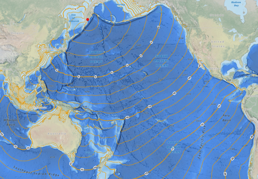
Figure 1. Estimated tsunami wave travel times from Petropavlosk, Russia, across the Pacific Ocean. Source: NOAA National Centre for Environmental Information[3].
Natural Catastrophe Program 2025

Related content
Identifying, quantifying, and managing tsunami risk
Tsunamis may be rare, but as history shows, their impacts can be devastating and far-reaching. To ensure risk from this complex peril is not overlooked, exposures can be identified through geospatial analysis, taking into account known subduction zones and research insights, such as those derived from paleotsunami studies. From there, a combination of scenario-based and probabilistic modelling can be used to estimate potential losses, drawing on factors like bathymetry, nearshore topography, and the vulnerability of local assets. Finally, through bespoke risk transfer solutions and broader risk management strategies, tsunami risk can be managed in the context of the overall catastrophe footprint.
References
- “USGS Overview". Return to article
- “USGS Did you feel it?". Return to article
- “NCEI Tsunami Travel Times to Coastal Locations Viewer". Return to article
- “On This Day: 2011 Tohoku Earthquake and Tsunami". Return to article
- “Runup Information". Return to article
- “Fisher, S., Goff, J., Cundy, A. and Sear, D., 2023. A qualitative review of tsunamis in Hawaiʻi. Natural Hazards, 118(3), pp.1797-1832,". Return to article
- “JetStream Max: Cascadia Subduction Zone". Return to article
- “Peters, R, Jaffe, B, Gelfenbaum, G. USGS. Cascadia Tsunami Deposit Database (2003),". Return to article
Authors