Severe thunderstorms with intense updraft cores create an ideal setting for the formation of large hail. These storms draw moisture from the lower troposphere and carry it to altitudes with sub-freezing temperatures, supporting ice particle formation and hail growth.
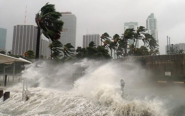
In regions like South Africa, hail has a long history of causing extensive damage to various exposed assets, including buildings, crops, infrastructure, and vehicles. One of the most extensively documented and devastating hailstorms took place on November 28, 2013, in Gauteng province. The reinsurance industry estimated losses of ZAR 1.4 billion[1] as a result of this event. Consequently, it is crucial to comprehend when, where, and under which conditions such incidents might transpire for insurance pricing and implementing preventive measures.
The sporadic occurrence and highly localized effects of hail make it challenging to quantify the hazard accurately, posing a unique obstacle to risk modeling. Reliable records of hailfall, including size information, are often limited to volunteer observer networks, databases, and hailpad networks, which have inherent limitations and may not provide comprehensive data for risk assessment.
Hail formation is not currently well-represented in numerical weather prediction or climate models due to the significant computational costs involved. Besides, our understanding of the involved microphysical and dynamical processes is still incomplete.
While remote sensing data from radar, along with convection-related parameters from numerical models, show promise in determining hailstorm spatial extent and better understanding of related atmospheric conditions, they also come with limitations, such as limited radar coverage, limited duration of reliable historical radar data, signal attenuation, and simplified model microphysics.
Geostationary satellites offer a broader coverage area compared to radar and provide more homogeneous data, making them valuable tools for the analysis of hailstorms. While they may be less accurate in hailstorm detection than polar-orbiting satellites with microwave-wavelength sensors[2], they excel in identifying severe convective storm clusters at high temporal resolution (e.g., every 15 minutes) through the detection of overshooting cloud tops. Overshooting cloud tops are transient intrusions of tropospheric air into the lower stratosphere, and therefore serve as indicators or proxies of intense updrafts within a thunderstorm cloud that can generate hail. Geostationary satellites utilize infrared cloud-top temperature data to identify these features, thereby inferring the potential for hail formation. Infrared temperature is also used to estimate storm severity and potential hail size, based on recent research that shows that the largest hailstones are most often generated by the coldest overshooting tops[3].
The availability of such data enables not only the global analysis of hail occurrence but also the identification of prevailing atmospheric conditions during individual hailstorms. By examining the characteristics of hailstorms on a global scale, researchers can gain insights into the geographical distribution, frequency, and intensity of hail events.
As discussed in a recent WTW Research Network’s insight piece on Earth Observation and Machine Learning[4], the use of satellite imagery has the advantage of being able to cover large areas as well as provide ever-increasing resolution on local scales, and allows for observation even in remote locations.
In addition, high-performance computing, AI, and machine learning techniques give the ability to process and identify features from large quantities of satellite images without the need for significant resources. However, unlike with geohazard assessment, ground-based observation of phenomena such as overshooting cloud tops is extremely limited, so advances in remote Earth Observation continues to have profound impacts on the ability to accurately monitor, interpret, and assess hazard and risk from hailstorms.
The Karlsruhe Institute of Technology (KIT), in collaboration with NASA’s Langley Research Center and Marshall Space Flight Center, has maintained a longstanding partnership with the WTW Research Network to address the challenges associated with hail hazard and risk assessment.
Punge et al. (2014, 2017)[5] [6], previously utilized the overshooting cloud tops approach to estimate a comprehensive hail event dataset for Europe. This dataset served as the foundation for the development of the Willis European Hail Model, which stands as the first fully randomized stochastic hail model covering the entire European region. Since its inception in 2014, the model has become a standard tool utilized by insurance and reinsurance companies throughout Europe for hail risk estimation and pricing. Encouraged by its success, a similar approach was subsequently employed to assess hail risks in Australia[7]. For this model, additional radar data, mainly from coastal regions, allowed to refine the resolution of the hail assessments.
However, it is important to note that many emerging insurance companies and markets worldwide lack such comprehensive assessments. South Africa serves as a prime example, where hail is a frequent hazard and a significant driver of risk yet there is a dearth of comprehensive hail risk evaluations in the country's insurance industry.
To bridge this gap, WTW Research Network researchers have proposed a novel approach utilizing 14 years of geostationary satellite observations. By leveraging the detection and tracking of overshooting cloud tops, coupled with depictions of hailstorm environmental ingredients derived from reanalyses, the researchers uncover, in their recently published paper[8], the spatiotemporal patterns associated with potential hail events across South Africa. Their key findings offer valuable insights for estimating hail risk across the country, particularly as these outbreaks contribute significantly to damage and require accurate estimation to address insurers' solvency concerns.
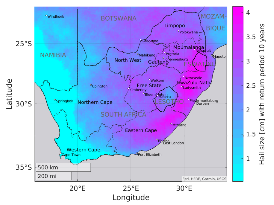
Hail events in South Africa primarily concentrate in the southeast, along the Highveld, and around the eastern slopes (Figure 1).
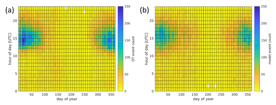
Hail events are most frequent from mid-November through February, peaking in the afternoon between 13:00 and 17:00 UTC (Figure 2).
By applying multivariate stochastic modelling, they have created a comprehensive event catalog spanning 25,000 years. This catalog, in combination with vulnerability and exposure data, can estimate hail risk for return period of 200 years.
For the Willis South Africa Hail Model, the researchers utilized enhanced overshooting cloud top detection and a new tracking algorithm for the overshooting top data[9] , allowing for a more precise description of the spatiotemporal extent of potential hail events (Figure 1). This model is also capable of handling multiple events per day as well as their spatial spread and multi-year variability, both considered in the stochastic modelling of the event set (see Figure 2). By explicitly including the date as an event properly, it has become possible to represent outbreaks with multiple events on a single day in a realistic way.
As such, the combination of improved overshooting cloud tops detection, reanalysis data, and advanced spatio-temporal clustering techniques allows for a much more precise determination of hail hazard zones compared to the method employed in the Willis European Hail Model[2].
This novel approach, based on geostationary satellite observations, provides insurers and reinsurers with a valuable tool for estimating and pricing hail risk in South Africa. Accurate characterization of hail hazard enables targeted preventive measures and resilience-building efforts. Stakeholders can utilize these insights to develop strategies for protecting exposed assets, such as crops, infrastructure, and vehicles.
By leveraging geostationary satellite observations in combination with reanalysis data, it becomes possible to overcome data scarcity challenges. Geostationary satellites offer a broader coverage area and provide homogeneous data, allowing for the identification of severe convective storm clusters through the detection of overshooting cloud tops. This approach can be adapted for other regions, enabling a comprehensive understanding of hail hazard patterns, seasonal variations, and temporal dynamics. Therefore, the method presented in the paper holds immense applicability for other regions like Brazil, Paraguay, Uruguay, and Argentina, where hailstorms are often reported, but limited information and data on hail sizes and frequency hinder accurate risk assessment. As such, using a similar model approach, WTW Research Network Fellow Jannick Fischer from KIT is currently performing hail hazard analysis for South America.
By embracing this innovative method, the insurance and risk management sectors can gain valuable insights into hail risk, enabling them to refine pricing strategies and implement proactive measures to safeguard assets and enhance overall resilience.