
El Niño has already been declared for the tropical Pacific Ocean. Some models predict it will by year’s end become the strongest event since (at least) the middle of the 1800s. Because El Niño conditions often suppress the formation of hurricanes in the north Atlantic, many people in the insurance industry have (understandably) been focused on its potential effects on the current hurricane season. In a June 29 webinar hosted by Willis Re, Willis Research Fellow Dr. James Done highlighted the state of the tropical Pacific as one of three key ingredients that determine the character of the 2026 North Atlantic hurricane season.
But the effects of El Niño are global and extend far beyond the activity of tropical cyclones. Once established, El Niño conditions can persist for several months. The US Climate Prediction Center expects the current event will last until April 2027 and could continue afterward[1]. This set-up offers insurers and their clients the rare opportunity to prepare for unusual weather five to eight months in advance — if we have the right tools at hand.
For many decisions that depend on future weather conditions, the "right tool" is an Earth system model. An Earth system model is a physics-based representation of the atmosphere, ocean, land surface (and more) that can be spun up with today’s weather conditions to predict the conditions of the future. Run on supercomputers with tens of thousands of processors working in parallel, these state-of-the-art models are used in an enormous range of scientific applications, such as studying the weather on ancient “Snowball Earth” or gauging the odds of drought for California winegrowers next month. The fact that we knew way back in January that El Niño was on its way is thanks to Earth system models and our understanding of fundamental physics.
Tropical origins, global effects
The origins of El Niño (and its counterpart, La Niña) lie within the tropical Pacific Ocean. As the Earth’s largest ocean, the Pacific acts as a massive engine that directs the flow of air, moisture, and heat across a large fraction of the planet. During an El Niño, the typical wind and ocean currents in the tropical Pacific basin get moved, reversed or rearranged. Those changes lead to unusual weather in places that surround the Pacific basin. They also spill over to affect regions much farther.
El Niño is in the news quite often right now, so it’s worth recalling a few key facts about it:
- El Niño is a natural phenomenon. The earliest written description of El Niño was made by the Spanish conquistador Francisco Pizarro in 1525[2] Geological evidence suggests the seesaw between El Niño and La Niña has been ongoing for thousands of years.
- Despite its name, the El Niño-Southern Oscillation is not a cycle. Instead of repeating on a regular schedule (like your birthday or the orbit of the moon), El Niño and La Niña happen irregularly, roughly every two to seven years. Think an irregular heartbeat, not a metronome.
- Based on our experience with past El Niño events, we can anticipate its typical effects on weather elsewhere. These remote associations (called "teleconnections") tell us that El Niño usually begets drought to southeast Asia and Oceania, heavy rains and flooding to southern California, and warmer winter weather to the Pacific Northwest (and other impacts elsewhere).
Although they share the same basic characteristics, every El Niño is unique. And despite its importance, it is always only a single factor that’s part of a complex and constantly changing planet. So, while looking back at past El Niños can help us know what to expect, we should regard these teleconnection patterns as tendencies, rather than being set in stone. If we want to anticipate the weather effects of the 2026-27 El Niño before they happen, then we need to model the current event as it’s unfolding on the planet today.
The monster on the horizon
We usually gauge the strength of El Niño events by measuring the temperature of the water at the surface of the tropical Pacific Ocean[3]. The 2023/24 El Niño reached a peak of +1.5ºC. The strongest event on record (which goes back to 1950) happened in 1982/83, when the index reached a maximum of +2.5ºC. Experts are still cautious to predict how strong the current event will be: In June, NOAA's lead ENSO forecaster, Michelle L'Heureux, said that, while it’s near-certain that El Niño will continue, the peak intensity of this event is still a “wild card”[4]. But currently all seasonal forecast models predict a top five event, and some suggest 2026/27 will be the strongest El Niño in living memory.
If the 2026/27 El Niño does end up as a record smasher, the more likely it will be to end up scrambling weather around the globe. But forecasting its effects would be complicated by the fact that we’d be dealing with a situation completely beyond our past experience. In other words, we don’t have a good analog for what’s yet to come.
Applying physics to divine the future
During El Niño events, we expect local weather around the tropical Pacific to be disrupted in predictable patterns. Drought and wildfire for Australia and Indonesia. Heavy rains over the Galapagos Islands. But each El Niño acts to perturb global weather in its own unique way. Using Planette’s hybrid physics-AI long-range weather intelligence system, here are seasonal forecasts for three places we expect to be strongly affected by the 2026-27 El Niño:
California
California is one of the main places where we expect substantially more precipitation due to the coming El Niño. In a typical year, the state receives between one foot and 3.5 feet of precipitation, and conditions in the tropical Pacific are responsible for about half of the year-to-year variation. California’s wet season, which usually extends from late November to March, is expected to be even wetter than usual (Figure 1). This wet weather will produce a heavy snowpack over the interior mountains (including the Sierra Nevada), which would be good news for the state’s water supplies. But heavy rainfall could also lead to flooding and landslides, especially in mountainous regions where forests have recently burned.
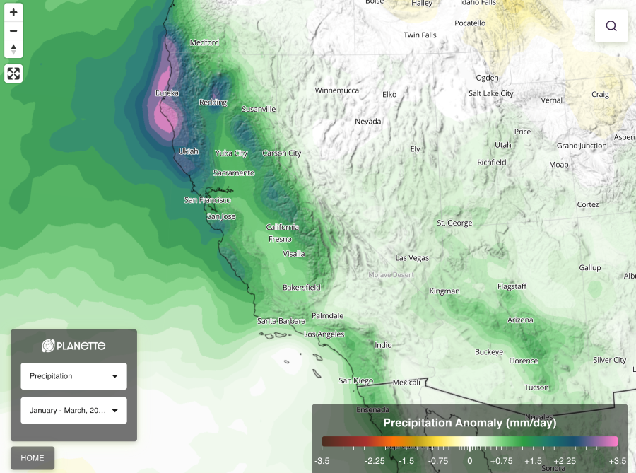
Figure 1. Models predict California will receive much more precipitation (rain and snow) than usual. Coastal communities and the interior mountains are likely to experience very wet winter weather (spanning January to March 2027).
Costa Rica and Panama
El Niño events often lead to dry weather over large swaths of Central and South America, and we expect that pattern to emerge in force later this year. Most years, a pattern of atmospheric wave activity known as the Madden-Julien Oscillation travels west to east, starting in east Africa, passing over southeast Asia and Oceania and eventually reaching the Pacific coast of South America. During El Niño, the moisture carried by this wave gets “stuck” in the middle of the tropical Pacific Ocean and cuts off Central and South America from an important seasonal moisture supply. Our projections this year (Figure 2) show unusually dry conditions – 20 to 50% drier - in October and November, which are often the wettest months of the year. Panama is already experiencing a water deficit and the Panama Canal, which relies on rainwater to fill the 50-mile passage between the Atlantic and Pacific, has been operating at reduced capacity since July due to drought. We expect El Niño-induced dry weather to prolong this drawdown, which could create additional pressure on marine transport and global supply chains.
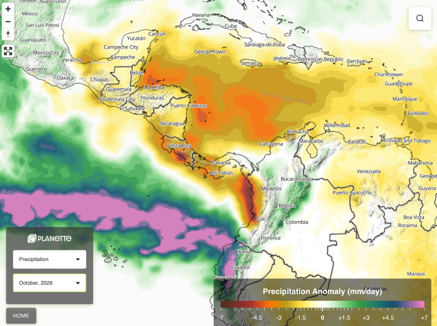
Figure 2a. The emerging El Niño is projected to cause unusually dry weather during October and November to Costa Rica, Panama, and the Pacific coast of Colombia.

Figure 2b. The emerging El Niño is projected to cause unusually dry weather during October and November to Costa Rica, Panama, and the Pacific coast of Colombia.
“Organizations in Latin America could face a period of heightened vulnerability in the coming months associated with the development of El Niño. In this context, proactively managing climate risk can strengthen organizational resilience, minimize financial and operational impacts, and improve response capabilities.”Roman MesuracaRegional Head of P&C - LatAm
Reduced solar energy production
On top of its impact on regional water supplies, El Niño also affects other aspects of the weather. One common impact is energy production from renewable sources, because the amount of sunshine and strength of the wind depends on the atmospheric circulation. Because of the current El Niño, we expect the amount of available solar energy to decrease by 5-15% from January through March (Figure 3). Our forecasts also indicate a parallel slowdown in available wind energy, suggesting that other energy sources may be needed to meet residential, commercial, and industrial electricity demand this winter.
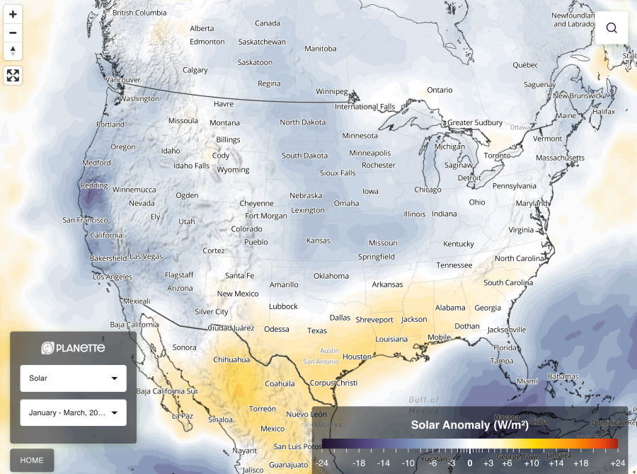
Figure 3. The ongoing El Niño should make much of North America cloudier this winter, which would reduce solar radiation and electricity production from solar energy facilities.
“Past El Nino events have materially affected renewable energy production by altering cloud cover, storm tracks, precipitation, and wind patterns. Based on forecasts of a developing El Nino, renewable engery producers in the United States and Canada should assess potential regional impacts on solar, wind and hydro generation, as some areas may experience below-average output during the winter season.”Rob HaleGlobal Head of Power and Renewable Energy
Forewarned, forearmed
The prospect of a record-setting El Niño is a daunting proposition. Although El Niños happen quite commonly, they still act as disruptors to nature, people and the economy. The combination of high global temperatures plus a strong or strongest-ever El Nino has increased the odds that 2027 will be the hottest year on record. Research led by researchers at Dartmouth University found that recent El Niño events cost trillions in lost income worldwide[5]. By analogy, we might expect the developing El Niño to have a similar impact on the global financial system.
Insurers and their clients may take some solace from the fact that El Niño tends to suppress tropical cyclone activity in the North Atlantic and so lessens the chances of catastrophic losses from hurricane damage. But El Niño’s impact goes far beyond dampening North Atlantic hurricanes. Experience does give us a foundation to anticipate its influence on particular places, perils, and problems. But in a changing world where the future will not look exactly like the past, physics-based models offer our best opportunity to see ahead several months and get prepared for El Niño-caused disruptions.
Footnotes
- US Climate Prediction Center (2026), El Niño/Southern Oscillation diagnostic discussion. Issued July 9, 2026. El niño/southern oscillation (enso) Diagnostic discussion. Return to article
- Enfield, D.B. (1989), El Niño, past and present, Reviews of Geophysics 27, 159-187. Return to article
- Climate Prediction Center, Relative Oceanic Niño Index, National Weather Service, Cold & Warm Episodes by Season. Return to article
- “Climate.us, Q&A with NOAA El Niño expert Michelle L'Heureux, June 23, 2026. Return to article
- Dartmouth University (2023), In Years After El Niño, Global Economy Loses Trillions. Cold & Warm Episodes by Season. Return to article
Authors