Observations and climate modelling studies indicate that La Niña often leads to atmospheric blocking (reduced storminess) in the early winter and enhanced westerlies (increased storminess) in the late winter,. The recent La Niña may therefore partially explain the absence of intense storms in early winter but fails to account for the late winter period.
The Madden Julian Oscillation (MJO), a natural weather pattern significantly impacting tropical regions and global weather, also played a crucial role during this winter. The MJO progresses through distinct phases, each representing different weather patterns. Extensive research supports the notion that the MJO has notable effects on the North Atlantic region,Phases 6 and 7 of the MJO are particularly associated with heightened rainfall and storm activity in the western Pacific Ocean, which can influence weather patterns in the North Atlantic area, causing blocked conditions (and therefore reduced storm activity over Europe) for up to two weeks.
Late November 2022 witnessed an exceptionally intense period characterized by phases 6 and 7 of the MJO. This heightened MJO activity was then followed by a relatively calm and cold period observed in early to mid-December 2022.
Throughout the winter, the MJO remained active, with recurring significant shifts to phases 6 and 7, followed by subsequent transitions to cooler periods. These patterns culminated in a sudden stratospheric warming (SSW) event.
Sudden stratospheric warming events are often (in ~70% of cases) followed by colder periods with easterly winds over northern Europe compared normal,,. These circulation patterns correspond to a weaker jet stream with less frequent windstorms.
While sudden stratospheric warming events are often involved in cold winters, they represent a challenge for seasonal forecasts due to their relatively short lead time for prediction.
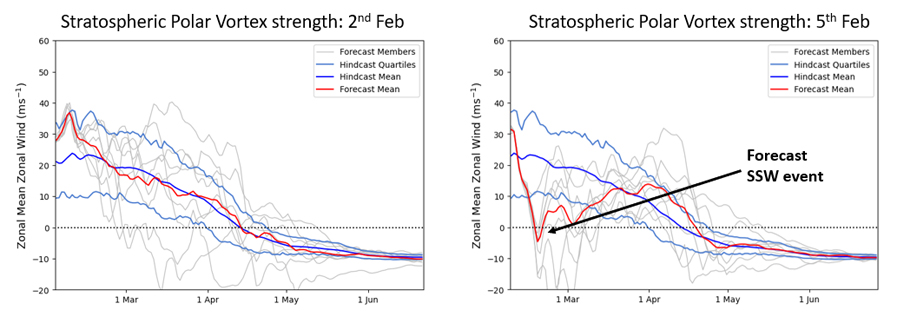
Figure 2 illustrates the emergence of forecast signals for the sudden warming of 2023, which were not apparent until early February. This late winter sudden stratospheric warming event likely contributed to reduced storminess in later winter when we would have otherwise expected increased storminess from La Niña.
In summary, it is likely that a combination of La Niña, intense MJO activity, and a sudden stratospheric warming event weakened the storm track in winter 2022/23.
Some of these signals, such as the La Niña event, were predicted in advance of the winter, and official Met Office long-range outlooks captured the weak winds and lack of storms observed over the UK throughout the winter (Figure 3).
The forecasts also highlighted that the risk of stormy weather was highest in late winter, aligning with the late winter La Niña teleconnection, which tends to strengthen the storm track in the Atlantic. However, the effect of La Niña was reduced this year due to a sudden stratospheric warming in February.
All data or statistics were correct at time of publishing.