An unprecedented set of oceanic warning signals
The big signals for this year’s North Atlantic hurricane season lie in the oceans. Unusually high heat arrived in the North Atlantic in early 2023 and has persisted into 2024. Record sea surface temperatures have occurred somewhere in the North Atlantic every day since last summer. Indeed, parts of the North Atlantic were as hot in May 2024 as they typically are in August. This heat is already contributing to impacts with torrential flooding rains across South Florida in mid-June.
It’s not just the ocean surface that is unusually hot. The high heat also extends a few hundred meters beneath the surface. This deep column of hot water is essential to power the most intense hurricanes. Alarmingly, the pattern of heat across the North Atlantic Ocean closely resembles the pattern that has historically produced the most active seasons.
Meanwhile, over in the equatorial Eastern Pacific
Ocean, a rapid cooling is under way signaling the
imminent arrival of La Niña. History tells us that
La Niña boosts seasonal hurricane numbers by
limiting strong winds aloft over the tropical North
Atlantic, which would otherwise disrupt and break up
developing storms.
Last year, the looming issue for hurricane forecasters
was whether the record heat in the North Atlantic
Ocean would win out over the hurricane-suppressing
effect of El Niño. In the end, the North Atlantic’s
influence was clearly the strongest
This year there is no such competition. I expect the
Atlantic and Pacific oceans to work together in the
same direction and create an active — perhaps even
hyperactive — hurricane season. However, we must
also remember that hurricane forecasters are working
in uncharted territory. We have never experienced
such exceptionally hot conditions in the North Atlantic
at the same time as an expected La Niña. Because
of the unprecedented heat in the North Atlantic,
hurricane experts who forecast the expected
number of storms using an analog approach are
struggling because none of the previous years have
similar conditions.
What can we say about landfall?
A critical component of seasonal storm activity is how
much of it will affect land. Yet this is often overlooked
because forecasting seasonal landfall activity is so
difficult. The National Oceanic and Atmospheric
Administration does not comment on landfall in its
seasonal outlooks. Its position is that landfall is largely determined by weather patterns as storms get closer to the coast and that these daily weather patterns cannot be predicted in advance of the season.
Colorado State University (CSU) does produce
predictions of the probability of storms making
landfall along the Atlantic Coast of the U.S. Those
landfall forecasts are founded on the observation
that storm activity in the western half of the North
Atlantic is usually higher during La Niña than El Niño.
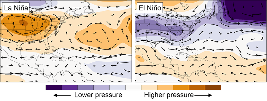
This association is likely due in part to the fact that atmospheric circulation patterns over the North Atlantic tend to steer storms toward the American coastline during La Niña and away from the coastline during El Niño (Figure 1). In 2023, for example, a strong El Niño combined with a weakened subtropical high to keep most storms away from the coast and safely out at sea.
As of June 2024, the North Atlantic subtropical high
seems to be getting stronger, and this trend is one
of the factors underlying CSU’s forecast of higherthan-normal landfall risk. At present, CSU’s group
anticipates the probability of at least one major
hurricane making landfall in the U.S. to be 50%
higher than the average hurricane season. But again, forecasting hurricane landfall is more difficult than
predicting the total number of storms. The uncertainty
in seasonal landfall is reflected in the large range
of U.S. landfalling hurricane numbers among CSU’s
analogue years (1878, 1926, 1998, 2005, 2010, 2020)
of between zero (in 2010) and six (in both 2005 and
2020). And these forecasts also apply to very broad
geographic areas: Landfall forecasts are available
for the entire U.S. Atlantic Coast, the East Coast and
the Gulf Coast. It’s not currently possible to make
landfall forecasts in advance of the season specific to
particular states or communities.
There is much to learn about our ability to forecast
steering flow and landfall activity in advance of the
season. Each year, only a few storms occur, providing
us with a limited amount of data, which makes
it difficult to identify patterns and relationships;
however, emerging evidence shows that frequencies
of some daily weather patterns may be somewhat
predictable in advance of a season.
Storm genesis locations may also be important in
determining landfall risk. Indeed, new evidence is
emerging over many seasons that genesis location
is more important than steering flow for determining
landfalling storm tracks, 5 and there is opportunity
to improve our ability to forecast preferred genesis
regions before the start of the hurricane season.
Given the explosion of advanced statistical techniques
in the atmospheric sciences, we can expect to see
a proliferation of machine-learning-based seasonal
hurricane predictions that will no doubt start to
produce regional landfall predictions. Improving
our ability to estimate the number of storms that
cross over to land and their likely trajectories is
an exciting and important emerging priority for
hurricane research.
In summary, all signals are pointing to a very active
season. Perhaps one factor that could make a dent
in the forecast is Saharan Air Layer outbreaks. These
could mitigate some of the record warming, and the
dry and dusty air could interfere with storm formation.
Irrespective of any potential mitigating factors, the
ceiling on the Atlantic hurricane season numbers has
never been so high.


