When a serious natural disaster happens that incurs significant loss of life, we in the hazard and risk advisory industries work to determine the causes and understand the scientific implications behind the event. But in addition to this, it is also important to understand the compounding hazards and human factors that have contributed to the destruction and human cost.
The largest magnitude Mw7.8 mainshock event to strike Turkey recently occurred at 1:17am UTC (4:17am local time) on Monday the 6 February, with an epicentre located at 37.166°N, 37.042°E at 17.9km depth (USGS Earthquake Hazards Program1). This was ~30km north-west of the city of Gaziantep, and ~45km north of the border with Syria. The earthquake was a 300km long left-lateral strike-slip rupture between the Anatolia and Arabia plates, consistent with the motion of the East Anatolian Fault which has a slip rate of 6 – 10mm/year (Temblor Inc.2). 9 hours after this event, a Mw7.5 aftershock event occurred ~95km to the north-west, ~20km north of the town of Elbistan at a depth of 10km. This was a 100km long right-lateral strike-slip rupture along a sub-fault of the East Anatolian Fault Zone, likely the Sürgü-Çardak fault. As the magnitudes of these two events were so similar, some academics have suggested that these were two separate mainshock events. However, stress changes calculated by Temblor’s ‘RealtimeRisk’ model suggests the first Mw7.8 event added stress to adjacent parts of the East Anatolian Fault Zone, particularly to the northeast of the epicentre where the second Mw7.5 event was located. “This imparted stress brings faults closer to failure, and so are likely sites for large aftershocks” according to Ross Stein of Temblor Inc. Therefore, according to Temblor’s analysis, these two events do follow a mainshock-aftershock sequence.

Coulomb stress change for the Mw7.8 event shows increased stress, and therefore aftershock hazard, at the ends of the fault rupture and perpendicular to it. One perpendicular stress increase falls on the location of the Mw7.5 event.
Source: Temblor Inc.
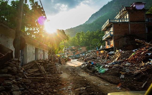
Given the shallow depth and large magnitude of both events, the shaking recorded at ground level was severe (50% of g Peak Ground Acceleration, or 50cm/s Peak Ground Velocity, according to USGS1) and resulted in large-scale damage to infrastructure. Surface rupture noted along roads and railway lines shows ~3m of displacement. Due to this significant movement of the crust from both events, aftershocks are likely to continue for weeks as other sub-faults within the East Anatolian Fault zone adjust to the stress changes caused. More than 200 aftershocks had been reported in the days immediately following the Mw7.8 and Mw7.5 events (Naddaf 2023), and have continued sporadically since. The most recent Mw6.3 event occurred on the 20 February, near the Turkish city of Antakya to the south-west of the two largest events.
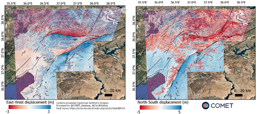
InSAR displacement for both events shows up to 3m east-west displacement and up to 5m north-south displacement, with movement to the north and east visible on the north side of both the East Anatolian and Surgu-Cardak faults.
Source: COMET
The Anatolian fault system is one of the most seismically active in the world. Within both the scientific and insurance industries, there has been a lot of focus on the North Anatolian fault; waiting for the section close to Istanbul to rupture in a repeat of the 1766 earthquake and tsunami. For this reason, the East Anatolian fault has seen less attention. Additionally, over the past 100 years the most destructive seismic events have occurred further north; in 1939 (Erzincan) and 1999 (Izmit). Professor James Dolan from the University of Southern California states that due to the East Anatolian fault system being younger and previously producing events in the Mw6.8 – 7.2 range, earthquakes of the size seen on 6 February were unexpected3. Population growth is another key factor to consider; since the 1999 Izmit earthquake World Bank data shows a 35% increase in Turkey’s population. This combination of unexpectedly large risk and significant exposure growth begins to explain the devastation and loss seen.
Other geological hazards were also noted as a result of the earthquakes; with a heightened risk of landslip for many hillsides in the region, liquefaction for certain geologies posing a higher risk to buildings (a major cause of damage during the 1999 Izmit earthquake in Turkey), tsunami risk in the Mediterranean Sea (a 30cm tsunami was recorded at Erdemli in Turkey following the Mw7.8 event, according to USGS and IOC), and subsidence of coastal areas causing flooding ~200m inland4.
Fires from damaged services such as ruptured gas lines also present an ongoing risk. These compounding hazards are likely to cause further injuries and deaths, impede rescue and relief efforts, and cause further damage to infrastructure. Evidence has surfaced through social media of large lateral flow landslip affecting roads around the earthquake epicentres, including failure of embankments and debris from slope failure causes blockages. Retaining wall failure also may have contributed to the partial collapse of Gaziantep Castle, a structure that has survived since the 3rd century AD.
In the city of Gaziantep, close to the Mw7.8 event’s epicentre, severe damage was to be expected due to the construction of buildings being predominantly low-rise, brick-built and close together (Kelam et al. 2022). However, footage of extensive damage, ‘pancaking’ (where the floors of buildings are piled up on one another) and collapses of more modern reinforced concrete buildings such as high-rise apartment blocks and hotels are also being seen in news outlets. This raises another important compounding hazard which has contributed to the high human cost of the disaster; building regulations and safety standards.
In an article by the BBC, a number of destroyed buildings seen on social media have been found to have been constructed as recently as 2018 and 2019, and reported upon completion to be fully compliant with all the latest earthquake regulations5. This would mean the use of high-quality concrete reinforced with steel bars, should mean that such buildings can withstand the shaking of a large-magnitude earthquake. However, adherence to these construction standards in many cases cannot be verified, and despite tightening of regulations following previous events such as the 1999 Izmit earthquake, there is evidence of poor building practices and enforcement in the name of cutting costs. Reports have circulated of the plastering over of structural cracks from previous earthquakes with no checks of integrity, use of poor-quality building materials such as marine sand with a high salt content in concrete, and removal of columns from ground floors to make space for retail developments leading to ‘soft storey failure’6. In addition, fines for non-adherence with regulations appear to have been waived in many cases to allow for more new developments in less time. Like the enforcement of regulations, many of these reports also cannot be verified, but when comparing the damage of many modern buildings with those in other earthquake-prone countries such as New Zealand and Japan, stark differences are apparent. In Syria, years of war have made the enforcement of building standards impossible. A number of buildings have been damaged as a result of conflict, and are subsequently rebuilt with whatever low-cost materials are available (Naddaf 2023).
On the other hand, although a lot of building damage is being blamed on poor adherence to earthquake resilience regulations and substandard construction materials/practices, there is an argument to be made that the damage from such large and shallow earthquakes could not be avoided in some places. In areas close to the Mw7.8 fault rupture, the USGS and AFAD recorded maximum PGAs of ~0.79g. Temblor Inc. has modelled PGAs in excess of 1g immediately surrounding the fault. For context, unreinforced masonry is not considered suitable for construction in any areas liable to PGAs over 0.25g, and although regulations vary between countries many earthquake-prone regions design buildings to withstand shaking up to ~0.5g (Nienhuys 2015). Shaking during this earthquake is thought to have exceeded even the rarest predicted one-in-2,475-year event stipulated for buildings to withstand in regulations, so may be partially to blame for some of the destruction caused close to the fault7. Damage accumulation from a combination of the two large-magnitude events and subsequent hundreds of aftershocks is also likely a contributing factor. An example from Central Italy in 2016 showed an increase in building collapses from 4% following the Mw6.2 mainshock, to 65% following two Mw 5.9 and 6.5 aftershocks in subsequent months (Iacoletti et al., 2023).
At the time of publishing, the death toll from these earthquakes is reported to be over 50,000 between Turkey and Syria, with close to 80,000 more injured and over a million displaced and in temporary shelters in Turkey alone. As rescue efforts continue, those numbers are certain to rise significantly. The economic losses and business disruption too are bound to be extreme, with widespread damage to houses, offices, tourist destinations, utilities and transport links.
1% drop in Turkey's GDP due to the earthquake (EBRD)
The European Bank for Reconstruction and Development (EBRD) estimates that the earthquake in Turkey would result in a loss of up to 1% of the country’s GDP8, while Verisk estimates economic losses of over $20 billion USD and insured losses of over $1 billion and RMS estimates over $25 billion economic and over $5 billion insured losses9. This relatively high portion of losses to be covered by insurance is due to the state-backed ‘Turkish Natural Catastrophe Insurance Pool’ (TCIP), which is reinsured by providers in London and Bermuda10.
$25+ billion USD economic losses (RMS)
$20 billion USD in economic losses (Verisk)
$5+ billion in insured losses (RMS)
$1+ billion in insured losses (Verisk)
This was set up following the Izmit earthquake in 1999, when insurance take-up was only about 3% resulting in significant pressure on public budgets as homeowners relied on the government to cover reconstruction costs11. The situation following these recent events is much improved, with the latest figures from TCIP indicating that homeowner take-up rates are around 50% within the affected region. However, this still leaves a large protection gap, and with the annual rate of inflation exceeding 50% it is likely that government budgets will again come under some pressure12.
As the full scale of the disaster unfolds, both in terms of human and financial cost, the WTW Research Network and its partners in academia and industry will continue to use the latest in technological innovation and research to obtain accurate information and inform scientific understanding. It is hoped that by fully realising the nature of these earthquakes, and where engineering and policy failures have contributed to the damage and devastation seen, resilience measures can be improved both in Turkey and elsewhere across the globe to ensure we are better prepared for similar events in the future. A similarly large event is still anticipated on the North Anatolian fault close to Istanbul, so it is hoped that stricter enforcement of building regulations and retrofitting of existing structures will avoid a repeat of the devastation seen when it strikes.
Iacoletti S., Cremen G., Galasso C. (2023), “Modelling damage accumulation during ground-motion sequences for portfolio seismic loss assessments”. Soil Dynamics and Earthquake Engineering Volume 168, 107821.
Kelam, A. A., Karimzadeh, S., Yousefibavil, K., Akgün, H., Askan, A., Erberik, M. A., Koçkar, M.K., Pekcan, O., Ciftci, H. (2022). “An evaluation of seismic hazard and potential damage in Gaziantep, Turkey using site specific models for sources, velocity structure and building stock”. Soil Dynamics and Earthquake Engineering 154, 107129.
Naddaf, M. (2023). “Turkey-Syria earthquake: what scientists know”. Nature 614, 398-399.
Nienhuys, S. (2015). “Seismic building codes: global and regional overview”. Evidence on Demand, UK iv + 37pp.
1 USGS Earthquake Hazards Program
2 Stress change calculations provide clues to aftershocks in 2023 Türkiye earthquakes
3 Could Turkey’s deadly quakes be followed by more in the Middle East?
4 Geological impact of Turkey-Syria earthquake slowly comes into focus
5 Turkey earthquake: Why did so many buildings collapse?
6 Turkey earthquake: Experts believe collapse of buildings was preventable
7 Why was the destruction to buildings in Turkey so catastrophic?
8 Turkey earthquake could result in loss of up to 1% of country's GDP in 2023
9 Earthquakes in Turkey to Cost Insurers More Than $1 Billion, Verisk Estimates
10 High portion of Turkey’s earthquake losses to be covered by insurance
11 Turkish Catastrophe Insurance Pool
12 TCMB - Consumer Prices