main content, press tab to continue
Article | WTW Research Network Newsletter

Why have there been so few European winter windstorms in 2022/2023?

By Adam Scaife , David B. Stephenson , Matthew Priestley , Nicky Stringer and Daniel Bannister | July 20, 2023

The 2022/2023 European windstorm season was unusually quiet, deviating from predictions of heightened storm activity.
Aerospace|Environmental Risks
Climate Risk and Resilience|Insurer Solutions

Factors such as La Niña, the Madden Julian Oscillation, and a sudden stratospheric warming event likely contributed to the reduced storminess, highlighting the challenges of seasonal forecasting.

During the winter of 2022/2023, European extratropical cyclones, known for their destructive nature and significant impact, were notably scarce. This absence of named storms aligned with early winter forecasts but contradicted predictions that anticipated heightened storm activity later in the season. This raises the question of why there were so few storms in Europe during this winter. Understanding the factors contributing to European extratropical cyclone frequency is crucial, especially for industries like insurance and agriculture that depend on weather information.

Historically, the UK Met Office has recorded an average of 4.5 named European extratropical events per year since the naming convention was introduced in 2016. However, the 2022/2023 season stood out with only one storm (Otto) named by the Danish Meteorological Institute in February 2023. This stands in stark contrast to the previous year, which experienced a rapid succession of named events, including three within seven days (Dudley, Eunice, and Franklin) for the first time since the naming convention began. Despite the limited occurrence of named storms, the total number of extratropical cyclones during winter 2022/23 remained close to the average (Figure 1).

Image of Number of North Atlantic storms per Northern Hemisphere winter (Dec–Feb) since 1960 from Copernicus Climate Change Service.
Figure 1 : Number of North Atlantic storms per Northern Hemisphere winter (Dec–Feb). Despite the lack of named (intense) storms, the total number of storms was close to average in winter 2022/2023.

Data source: Copernicus Climate Change Service (C3S). Complete ERA5 global atmospheric reanalysis. DOI: 10.24381/cds.143582cf (2023).

The question arises: What happened to the intense windstorms this winter? Our initial null hypothesis is always that internal, unpredictable climate variability, with no particular identifiable cause, leads to variation between one period and the next. Some aspects of the quiescent winter of 2022/23 will no doubt be attributable to this unpredictable ‘chaos’. Individual seasonal forecasts showed substantial uncertainty and some of them did span the observed outcome, but can we dig deeper?

The global climate state for winter 2022/23 was influenced by the third La Niña event in a row since 2020.

Observations and climate modelling studies indicate that La Niña often leads to atmospheric blocking (reduced storminess) in the early winter and enhanced westerlies (increased storminess) in the late winter[1],[2]. The recent La Niña may therefore partially explain the absence of intense storms in early winter but fails to account for the late winter period.

The Madden Julian Oscillation (MJO), a natural weather pattern significantly impacting tropical regions and global weather, also played a crucial role during this winter. The MJO progresses through distinct phases, each representing different weather patterns. Extensive research supports the notion that the MJO has notable effects on the North Atlantic region[3],[4]Phases 6 and 7 of the MJO are particularly associated with heightened rainfall and storm activity in the western Pacific Ocean, which can influence weather patterns in the North Atlantic area, causing blocked conditions (and therefore reduced storm activity over Europe) for up to two weeks.

Late November 2022 witnessed an exceptionally intense period characterized by phases 6 and 7 of the MJO. This heightened MJO activity was then followed by a relatively calm and cold period observed in early to mid-December 2022.

Throughout the winter, the MJO remained active, with recurring significant shifts to phases 6 and 7, followed by subsequent transitions to cooler periods. These patterns culminated in a sudden stratospheric warming (SSW) event[5].

Sudden stratospheric warming events are often (in ~70% of cases) followed by colder periods with easterly winds over northern Europe compared normal[6],[7],[8]. These circulation patterns correspond to a weaker jet stream with less frequent windstorms.

While sudden stratospheric warming events are often involved in cold winters[9], they represent a challenge for seasonal forecasts due to their relatively short lead time for prediction[10].

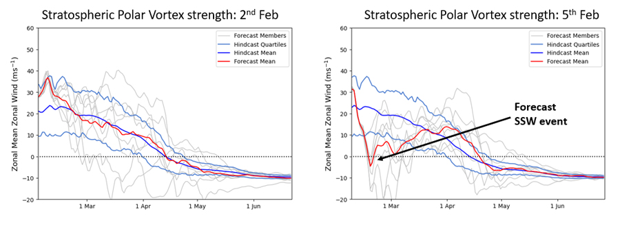
Figure 2 illustrates the emergence of forecast signals for the sudden warming of 2023, which were not apparent until early February. This late winter sudden stratospheric warming event likely contributed to reduced storminess in later winter when we would have otherwise expected increased storminess from La Niña.

Strength of stratospheric polar vortex as measured by daily windspeeds in stratosphere at 60N & 10hPa for late winter period from February '23
Figure 2 : Strength of the stratospheric polar vortex as measured by daily windspeeds in the stratosphere at 60N and 10hPa for the late winter period from February 2023. Forecasts from 2023 are shown in red and mean climatology is shown in blue. Note the emergence of a strong signal for a collapse of the polar vortex (and hence a sudden stratospheric warming) in forecasts made in early February.

Source: UK Met Office

In summary, it is likely that a combination of La Niña, intense MJO activity, and a sudden stratospheric warming event weakened the storm track in winter 2022/23.

Some of these signals, such as the La Niña event, were predicted in advance of the winter, and official Met Office long-range outlooks captured the weak winds and lack of storms observed over the UK throughout the winter (Figure 3).

The forecasts also highlighted that the risk of stormy weather was highest in late winter, aligning with the late winter La Niña teleconnection, which tends to strengthen the storm track in the Atlantic. However, the effect of La Niña was reduced this year due to a sudden stratospheric warming in February.

Met Office long range outlook for winter 2022/2023 issued in November 2022.
Figure 3. Met Office long range outlook for winter 2022/2023 issued in November 2022.

Source : UK Met Office

Footnotes

  1. Moron, V. & Gouirand, I. Seasonal modulation of the El Niño-Southern Oscillation relationship with sea level pressure anomalies over the North Atlantic in October-March 1873-1996. International Journal of Climatology 23, 143–155 (2003). Return to article
  2. Hardiman, S. C. et al. The impact of strong El Niño and La Niña events on the North Atlantic. Geophysical Research Letters 46, 2874–2883 (2019). Return to article
  3. Cassou, C. Intraseasonal interaction between the Madden–Julian Oscillation and the North Atlantic Oscillation. Nature 455, 523–527 (2008). Return to article
  4. Lin, H., Brunet, G. & Fontecilla, J. S. Impact of the Madden–Julian Oscillation on the intraseasonal forecast skill of the North Atlantic Oscillation. Geophysical Research Letters 37 (2010). Return to article
  5. Schwartz, C. & Garfinkel, C. I. Relative roles of the MJO and stratospheric variability in North Atlantic and European Winter Climate. Journal of Geophysical Research: Atmospheres 122, 4184–4201 (2017). Return to article
  6. Bett, P. E. et al. Using large ensembles to quantify the impact of sudden stratospheric warmings and their precursors on the North Atlantic Oscillation. Weather and Climate Dynamics 4, 213–228 (2023). Return to article
  7. Kidston, J. et al. Stratospheric influence on tropospheric jet streams, storm tracks and Surface Weather. Nature Geoscience 8, 433–440 (2015).Return to article
  8. Scaife, A. A. et al. Seasonal Winter forecasts and the stratosphere. Atmospheric Science Letters 17, 51–56 (2016). Return to article
  9. Fereday, D. R., Maidens, A., Arribas, A., Scaife, A. A. & Knight, J. R. Seasonal forecasts of Northern Hemisphere Winter 2009/10. Environmental Research Letters 7, 034031 (2012). Return to article
  10. Marshall, A. G. & Scaife, A. A. Improved predictability of stratospheric sudden warming events in an atmospheric general circulation model with enhanced stratospheric resolution. Journal of Geophysical Research 115, (2010).Return to article

Disclaimer

All data or statistics were correct at time of publishing.

Download
Title File Type File Size
Natural Catastrophe Review January - June 2023 PDF 5.5 MB
Authors

Met Office Hadley Centre and University of Exeter
email Email

University of Exeter
email Email

University of Exeter
email Email

UK Met Office and University of Exeter

Weather & Climate Risks Research Lead
WTW Research Network, WTW
email Email

Contact us