Where are all the hurricanes?
Statistically, 2022 so far has not been unusual. The season started off early enough with 3 named storms: Alex, Bonnie, and Colin but this year was the first since 2014 without a named storm before the official start of the season on June 1. Early August is when the North Atlantic really starts to light up, with August to October peak season for pulses of energy to track off the coast of North Africa, seeding the Atlantic with opportunities for storm formation. But given the forecasts for a very active season we were not expecting most of July and early August to be silent, which would be unusual even in an average year.
We can look to intra-seasonal variability to explain some of this surprise. A form of climate variability known as the Madden-Julian-Oscillation intermittently races around the global tropics acting to suppress or enhance thunderstorm activity and tropical cyclones as it goes. For most of July its unfavorable phase suppressed storm activity over the North Atlantic. In addition, dry air extended across much of the North Atlantic. These oppressive forces are expected to dissipate in August. If so, we’ll likely see a burst of storm activity in September. The National Oceanic and Atmospheric Administration (NOAA) also notes that activity in June-July is not closely correlated with activity in August-October.
The current situation has signals that the North Atlantic will likely ramp up on schedule. A pulse of energy has just tracked off the coast of North Africa and will become a focal point for possible storm formation over the central tropical North Atlantic over the next few days.
A New Normal
As a reminder, seasonal forecasts are often presented relative to normal activity. But what is normal? Normal activity is defined as the average over a recent 30-year period. Thirty years are long enough to average out climate variability but short enough to avoid including climate change trends. The thirty-year period was recently updated, and we now use the period 1991-2020 to give a more up-to-date version of ‘normal’. With most of this new period being in an active hurricane period, the new normal hurricane activity has shifted upwards to 14.4 named storms, 7.2 hurricanes and 3.2 major hurricanes. Compare that our previous normal activity of 12.1 named storms, 6.4 hurricanes, and 2.7 major hurricanes for the period 1981-2010. This represents an increase in normal activity of about 12-18%.
Forecasts
Available forecasts for early August from the major forecasting centers continue to call for above average activity (Table 1). For example, NOAA forecasts a 60% chance of above normal activity and just a 10% chance of below normal activity. However, these latest forecasts are a decrease of generally 5-20% in activity compared to the early-season forecasts. We note that these forecasts for above average activity are relative to the new higher averages and so these forecasts certainly still call for an active season.
Across all forecasts in Table 1, the number of named storms range from 11 to 21. For hurricanes the numbers fall within a range of 4 to 10, and for major hurricanes (Saffir-Simpson category 3-5) they range from 2 to 6. We note that NOAA and the UK Met Office forecast ranges of activity to reflect uncertainty in the predicted environment and uncertainty in the hurricane activity within that environment. They state a 70% likelihood of the numbers falling within these ranges.
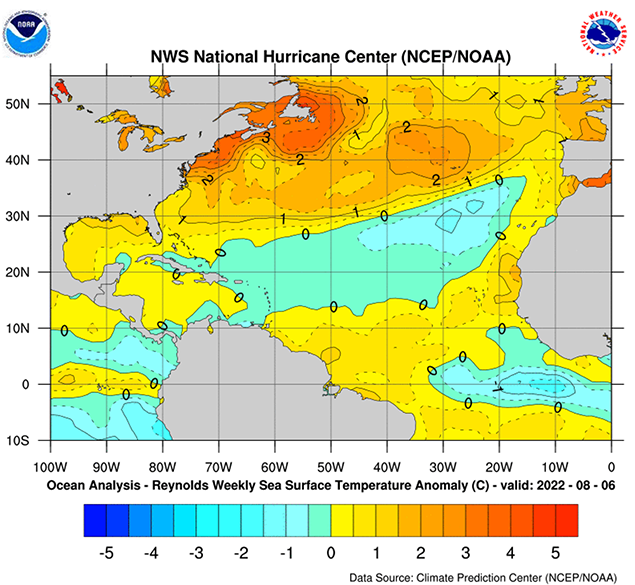
The reasoning behind the continued expectation of an active season includes climate predictions of supportive conditions in the Atlantic basin this season. Specifically, La Niña is expected to persist through the season which would suppress environmental winds aloft that are unfavorable for storm formation. NOAA also notes that the pulses of energy coming off Africa are set to track on a more northerly trajectory than normal which gives more background spin in the atmosphere and is more favorable for storm formation. Sea surface temperatures are forecast to be warmer than normal across the tropical North Atlantic, Caribbean, and Gulf of Mexico. However, CSU notes that cooler-than-normal subtropical North Atlantic waters could set the stage for some disturbed weather that could interfere with storm formation.